
DeZwerver.nl
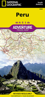
Wegenkaart - landkaart 3404 Adventure Map Peru | National Geographic
Wegenkaart - landkaart 3404 Adventure Map Peru | National Geographic
Verzendkosten € 2,95
18,50

Gevonden bij 1 winkel vanaf
€ 18,50
(minder betalen?)
- Waterproof - Tear-Resistant - Travel Map
National Geographic's Peru AdventureMap is designed to meet the unique needs of adventure travelers with its durability and accurate information. This folded map provides global travelers with the perfect combination of detail and perspective, highlighting hundreds of points of interest and the diverse and unique destinations within the country.
The map includes the locations of cities and towns with a user-friendly index, plus a clearly marked road network complete with distances and designations for major highways, main roads, and tracks and trails for those seeking to explore more remote regions.
The front side of the map shows the northern half of Peru including the regions of Loreto, Tumbes, Piura, Amazonas, Lambayeque, Cajamarca, La Libertad, Ancash, Huánuco, and Ucayali. This section of the map spans from Peru's borders with Ecuador and Colombia on the north and Brazil on the east, down to the coastal city of Chimbote. The regions of Tacna, Puno, Pasco, Moquegua, Madre de Dios, Lima, Junín, Ica, Huancavelica, Cusco, Ayacucho, Arequipa, and Apurímac are included on the reverse side.
Every AdventureMap is printed on durable synthetic paper, making them waterproof, tear-resistant and tough — capable of withstanding the rigors of international travel. Each is two-sided and can be folded to a packable size of (4.25" x 9.25"); unfolded size is (26" x 38").
Key Features:
- Waterproof and tear-resistant
- Accurate topography/terrain with a clearly labeled road network
- Hundreds of points of interest, including the locations parks and nature reserves, protected lands, historical and cultural attractions
- Thousands of place names including towns and natural features; detailed place names index
- Important travel networks including airports, lighthouses, ferry routes and rail lines
- Updated regularly to ensure accuracy
Proceeds from the sale of National Geographic maps go to support the National Geographic Society's vital exploration, conservation, research and education programs.