
DeZwerver.nl
Wegenkaart - landkaart Newfoundland & Labrador | ITMB
Wegenkaart - landkaart Newfoundland & Labrador | ITMB
Verzendkosten € 2,95
13,95

Gevonden bij 1 winkel vanaf
€ 13,95
(minder betalen?)
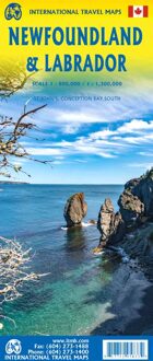
Double-sided map of Newfoundland and Labrador Provinces at 1:800,000 and 1:1,300,000 respectively, part of a series of maps of Canadian provinces from the Vancouver-based ITMB, with topography presented by altitude colouring rather than by relief shading.
Road and rail networks are shown on a clear base with numerous national or regional parks and wildlife reserves prominently marked. The Trans Canada Trail is prominently indicated; symbols highlight various places of interest, sport and recreational facilities, etc. National, provincial and time zone boundaries are displayed. The map has a latitude and longitude grid at intervals of 1º and an index of localities. Historical information is given on the outer edges of the map, with a small box showing the timeline of the provinces, dating back to the 11th century.
Also included are plans of Conception bay South and St. John’s, indicating one-way streets, points of interest, and various facilities.