
DeZwerver.nl
Wandelkaart - Wegenkaart - landkaart Kefallonia - Kefalonia | Freytag & Berndt
Wandelkaart - Wegenkaart - landkaart Kefallonia - Kefalonia | Freytag & Berndt
Verzendkosten € 2,95
14,95

Gevonden bij 1 winkel vanaf
€ 14,95
(minder betalen?)
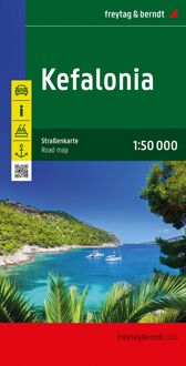
Goede wegenkaart van Kefallonia / Kefalonia, waarbij ook de kleinere wegen nog goed te lezen zijn. Gedetailleerde schaal van 1:50.000. Veel toeristische symbolen voor bezienswaardigheden als grotten, tempels, opgravingen maar ook mooie stranden etc.
Ook handig is de Nederlandstalige Reisgids van Kefalonia "Ontdek Kefalonia" "Ontdek Kefalonia"
Explore Kefallonia, the largest of the Ionian Islands located in Greece; with this Freytag & Berndt single-sided road and leisure map. The map will allow you to travel independently, and plan your journey well.
The map also features full colour photographs of some of the scenery to be found on Kefallonia, as well as an inset showing Kefallonia's position within the nation of Greece. An inset is also provided showing a city plan of the main township on Kefallonia, Argostoli. The topography is clear, with shading showing land gradients.
As with all Freytag & Berndt maps, icons and markings are used to denote tourist information and points of interest. These include:
Roads, both surfaced and unsurfaced and foot paths
Important facilities such as petrol stations, yacht supply stations, car ferries, ports and lighthouses
Places to see such as churches, monasteries, castles, museums, ruins and archaeological sites
Caves, spas and camp sites
Distances between points are shown in kilometres. The legend is in Greek, German, English, French, Italian, Dutch, Spanish, Czech, Slovak and Hungarian.