
DeZwerver.nl
Wandkaart Engeland - British Isles roadplanning wall map | 84 X 119 cm | Maps International
Wandkaart Engeland - British Isles roadplanning wall map | 84 X 119 cm | Maps International
Verzendkosten € 5,95
75,95

Gevonden bij 1 winkel vanaf
€ 75,95
(minder betalen?)
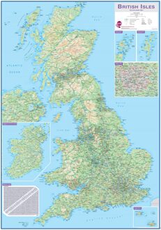
Routeplanner map from Maps International's selection of British Isles maps.
Routeplanning map details: British Isles routeplanning map shows the motorways, major roads and transport hubs such as airports and rail routes in the UK. Routeplanner maps shows the major towns and their approximate population in the British Isles. Routeplanner map also contains useful table of towns and their distance apart. Extremely useful in organising journeys - times and routeplanning.
Map Uses: This British Isles routeplanning map is ideal to display in offices or depots.