
DeZwerver.nl
Wandelkaart St Oswald's Way | Harvey Maps
Wandelkaart St Oswald's Way | Harvey Maps
Verzendkosten € 2,95
26,95

Gevonden bij 1 winkel vanaf
€ 26,95
(minder betalen?)
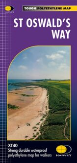
Mooie, duidelijke kaart van de St Oswald's Way Noord-Engeland. Geplastificeerd met veel extra informatie en uitsnedes van de route.
From Holy Island to Heavenfield, the 97 mile St Oswald's Way links some of the places associated with St Oswaldwho was the King of Northumbria in the early 7th century. The route runs through the Northumbria National Park following the stunning Northumberland Coast before heading inland across beautiful countryside to Heavenfield. It links with St Cuthbert's Way in the north and Hadrian's Wall Path in the south. Along the way you will encounter rolling farmland, villages, vast sandy beaches and fascinating history.
The HARVEY series of Long Distance Route maps is an established success. Now the advanced technology used in the creation of our best-selling British Mountain Maps is also applied to the route maps.
These maps are a leap forward in technical excellence. They are tough, durable, light and 100% waterproof - virtually indestructible in normal use.
They are light to carry, and compact - not the great bulky package you get with a laminated map.
The map is detailed, with the routes clearly marked. It also contains general information, useful telephone numbers and a full key.