
DeZwerver.nl
Magneetbord - Wandkaart British Isles - Groot Brittannië en Ierland, 61 x 76 cm | National Geographic
Magneetbord - Wandkaart British Isles - Groot Brittannië en Ierland, 61 x 76 cm | National Geographic
Verzendkosten € 5,95
189,00

Gevonden bij 1 winkel vanaf
€ 189,-
(minder betalen?)
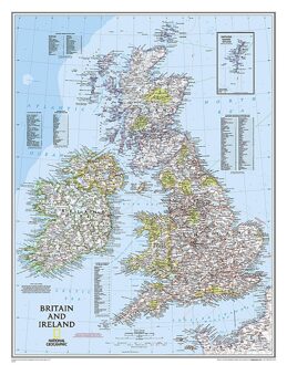
Magneetbord van een wandkaart van Groot Brittannië en Ierland: prachtig kaartbeeld met heel veel details, gemaakt door de gerenommeerde makers van National Geographic.
British Isles at 1:1,687,000 on a small wall map, 61 x 76cm (1’11” x 2’5” approx) , from the National Geographic Society showing the constituent parts of the United Kingdom, Irish Republic, Isle of Man and the Channel Islands. Shetland Islands are shown on an inset.
The map uses NGS’s classic presentation style of white background plus relief shading to show the topography, with boundaries shown in colour. Within Great Britain, national parks are prominently highlighted. Names of many geographical regions are shown (The Wolds, South Downs, etc.); county boundaries are marked, but county names are indicated only by numbers cross-referenced to lists of counties and unitary authorities in England, with corresponding lists for Scotland, Wales, Northern Ireland and the Irish Republic. Latitude and longitude lines are drawn at intervals of 1°.