
DeZwerver.nl
Wandelkaart Rif Occidental, Chefchaouen - Chauen | Editorial Piolet
Wandelkaart Rif Occidental, Chefchaouen - Chauen | Editorial Piolet
Verzendkosten € 2,95
14,95

Gevonden bij 1 winkel vanaf
€ 14,95
(minder betalen?)
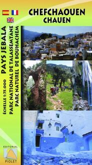
Gedetailleerde topografische wandelkaart van het westelijke Rifgebergte, Pays Jebala, het Parc national de Talassemtane en het Parc naturel de Bouhachem in Marokko.
De kaart bestrijkt een gebied met een straal van 25-30 km rondom Chefchaouen, grofweg tussen Es Soukkane, Oued Laou, Bkikcha en Beni Derkoul.
De kaart toont hoogtelijnen (interval 20 m), ingetekende wandelroutes, accommodaties, bezienswaardigheden, klimgebieden, etc. Op de achterzijde staat informatie over het gebied in drie talen (Engels, Frans, Spaans).
-------
Chefchaouen (Chauen) region of northern Morocco, south-east of Tangier and Tetouan, at 1:75,000 on a contoured and GPS compatible map from Editorial Piolet, highlighting recommended hiking trails, various tourist facilities and places of interest, etc.
Topography is vividly presented by contours at 20m intervals, enhanced by relief shading and altitude colouring. The map shows local roads, country tracks and footpaths, and highlights nine recommended hiking trails in the Talassemtane National Park, plus six more in the Bouhachem Natural Park. Symbols indicate various types of tourist accommodation (hotels, gîtes d’etape, campsites, bivouac zomes), restaurants, interesting natural sites, climbing sites, wildlife observation points, petrol stations, etc. The map has a UTM grid.
On the reverse are extensive notes about the area illustrated with colour photos, plus a list of useful contact details. Map legend and the text include English.